Large print $120. Dimension is 30″ square
Small print $50. Dimension is 19″ square
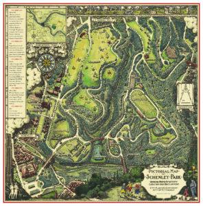
A charming vintage style map showing a bird’s eye view of Schenley Park in Pittsburgh. The Pittsburgh Golf Club and Schenley Park Golf Course are shown along with the roads, forests and trails of the park. Shades of green prevail making the topography of Panther Hollow and Junction Hollow clear. Once Frederick Law Olmsted designed Central Park in NYC, every city wanted to have a grand park and Schenley Park was Pittsburgh’s response. In the 1980s doing park research, found this beautiful illustrated “pictorial” map from the 1930’s, which was a black & white line drawing, possible drawn by Ezra Stiles. I added color and historical information. 3D drawings of buildings are shown including Carnegie Library Main Branch, Carnegie Music Hall and Carnegie Museum as it was in the 1930s. Also seen: Phipps Botanical Conservatory, the Cathedral of Learning at University of Pittsburgh, and early buildings on the campus of Carnegie Mellon University (CMU). Panther Lake is a brilliant turquoise blue to stand out from the greens. Along the top of the map are delightful vignette drawings of activities you can do in the park. The map includes some unbuilt projects such as an amphitheater and an elaborate pool which is where the skating rink is. Four bridges are drawn: the Greenfield Bridge, Schenley Bridge, Panther Hollow Bridge and the Charles Anderson Memorial Bridge. I changed the street names to the current names. Copyright with my changes and additions by Carol Skinger
More information about my map
